HOME > Technology
Technology
We always provide the best solutions for a safe and convenient life.
M-DRT
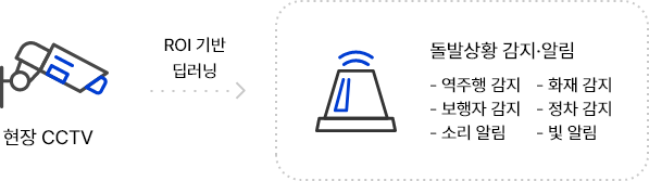
가상정류장 판단 모듈
Marker detection AI applies object recognition algorithms to identify markers, recognizing them from both near and far distances, unlike methods that only recognize from close range. Such marker detection AI exchanges information in real-time through marker recognition and is very cost effective from a production standpoint.
가상정류장 판단 모듈
-
Detection of markers for location awareness and necessary information request
- Recognizable from a distance (up to 15 m)
- Cost saving production through a simple marker recognition method that can be used via printout
Marker detection AI applies object recognition algorithms to identify markers, recognizing them from both near and far distances, unlike methods that only recognize from close range. Such marker detection AI exchanges information in real-time through marker recognition and is very cost effective from a production standpoint.
- Recognizable from a distance
- AI를 이용한 침수 여부 판단
RID
도로 침수 감지
RID, Road Inundation Detection
도로 침수 감지
-
Real-time CCTV flood detection possible
- Regardless of day or night, determine flood status through CCTV footage
- tilizes general road CCTV footage installed
-
AI flood detection uses general CCTV footage to determine flooding
- Can be immediately applied to existing general road CCTVs
- Quick inference speed allows real-time determination of road conditions
- A single server can monitor and infer from dozens of CCTVs in real-time
PMSS
주행 영상 분석
주행 영상 분석
-
Quantifying violation information from driving footage
- Quantitative evaluation feature of how well traffic regulations are adhered to during driving
- Scoring function for cars, motorcycles, and electric scooters
-
Personal Mobility Smart Scoring Model
- Use driving footage → Determine adherence to regulations
- Scoring function for signal violations, close vehicle driving, pedestrian crossing driving, sidewalk driving, and wrong-way driving
- Implementation of driving score function for various personal mobility vehicles
- 주행 영상에 대하여 점수화 가능
- 점수 판정에 대한 근거
- TAL-Pro 생성형 비식별화
AI object detection anonymization
www.talbakkum.com
-
AI-friendly anonymization solution
- Protect sensitive personal information such as faces and license plates in videos and photos
Anonymization object selection feature- Irrecoverable images post-anonymization
- Post-anonymization video editing feature
Anonymization Methods
1. Mosaic/Blur technique
2. Replacing personal information with generated images
ATF
교통 상황 분석
교통 상황 분석
-
Traffic situation analysis for congestion/accident classification
- AI traffic analysis classifies congestion and accidents by analyzing the movement and number of vehicles detected in real-time on CCTV, using a week's worth of CCTV footage, the traffic situation analysis solution applied to VisionON T performs real-time analysis on any road, enhancing the accuracy of its detailed analysis of stopping situations.
Real-time traffic flow detection and analysis- Applicable to any road situation
- 정체 감지
- 사고 감지
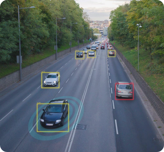
ADS
영상 유고 감지
ADS, Accidental Detection Solution
영상 유고 감지
- In the event of an emergency detection, speakers and flashing lights can be linked to immediately deliver an urgent warning alarm.
High accuracy based on deep learning AI- Real-time detection of up to 50 CCTVs
- Applicable to existing installed CCTVs
- Customizable types of emergencies
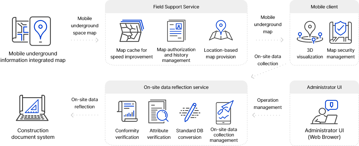
Mobile-based underground space map field utilization support system
- With the recent advancement in urban development, underground infrastructure such as electricity, water and sewage, gas, and heating systems , as well as underground structures necessary for city operations, are becoming larger. However, the integrated underground space maps that manage these are challenging to keep updated and accurate, posing a constant risk of major accidents during excavation, installation, or maintenance of underground facilities.
- In response, a mobile-based underground space map field utilization support system has been developed to utilize underground space information via mobile devices in a wireless environment, at construction sites, underground accident sites, and other locations where information on underground facilities is required.
- By utilizing this mobile-based underground space map field utilization support system, field workers can now receive large scale integrated underground space maps in real-time on-site via a wireless network, based on location. The convenience of 3D visualization of the underground space map enhances the ability to provide detailed information about the site, which was difficult to represent through 2D paper maps.
- 정확도 향상 기술 및 현장 활용 시스템과 연계
 Mobile underground information integrated map patent